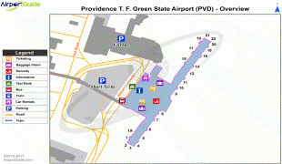
T. F. Green Airport (Theodore Francis Green State Airport)
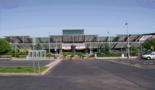
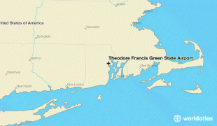
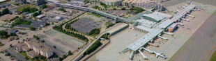
Rhode Island T. F. Green International Airport is a public international airport in Warwick, Rhode Island, United States, 6 mi south of the state's capital and largest city of Providence. Opened in 1931, the airport was named for former Rhode Island governor and longtime senator Theodore Francis Green. Rebuilt in 1996, the renovated main terminal was named for former Rhode Island governor Bruce Sundlun. It was the first state-owned airport in the United States.
The Federal Aviation Administration (FAA) National Plan of Integrated Airport Systems for 2017–2021 categorized it as a small hub primary commercial service facility.
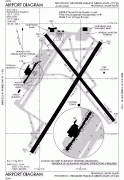
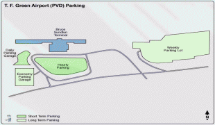
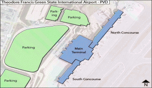
PVD covers an area of 1,111 acres (450 ha) and has two runways.
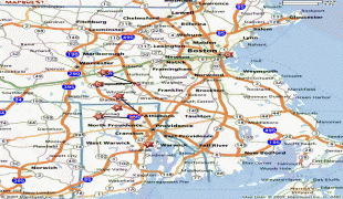
T. F. Green Airport is a regional airport serving the FAA's New England Region in the FAA System Plan. The airport is the largest and most active airport among the six operated by the Rhode Island Airport Corporation (RIAC).
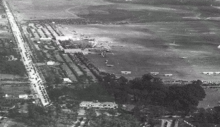
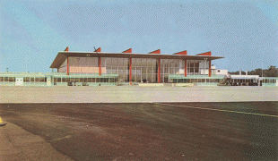
T. F. Green Airport was dedicated on September 27, 1931, as Hillsgrove State Airport, drawing what was at that time the largest crowd that had attended a public function in the country. In 1933, the Rhode Island State Airport Terminal was built on Airport Road, then called Occupasstuxet Road. In 1938, the airport was renamed in honor of Green, who had just been elected to the Senate two years earlier. At the time it had three 3000 ft concrete runways. The Army Air Force took control from 1942 to 1945, using it for flight training. The Sept 1946 diagram shows runways 5, 10 and 16 all 4000 ft long; in April 1951 runway 5 was 5000 ft and 5R was under construction. A few years later 5R was 5466 ft, which it remained until extended to 6466 ft around 1967.
The April 1957 OAG shows 26 weekday departures: 11 Eastern, 10 American, four United, and one National. Nonstops did not reach beyond Boston and Newark until 1959 when Eastern started a DC-7B nonstop to Washington, which was the longest until United started Cleveland in 1968 and Chicago in 1970 and Eastern started Miami in 1969 and Atlanta in 1970. The first jets were Mohawk BAC-111s in 1966.
President Richard Nixon made a campaign stop at the airport on the night of Friday, November 3, 1972. A crowd of 10,000 watched as Nixon, standing on the steps of Air Force One, urged voters to support Republican candidates Herbert F. DeSimone for Governor and John Chafee for U.S. Senator. (Both lost, though Chafee later won the office in 1976.) Air Force One again touched down at T. F. Green on August 30, 1975, this time carrying President Gerald Ford, en route to a fundraiser in Newport. He was greeted by a crowd of about 1,500 supporters, as well as local politicians including Governor Philip W. Noel, Senator John O. Pastore, and Providence Mayor Buddy Cianci.
The Federal Aviation Administration (FAA) National Plan of Integrated Airport Systems for 2017–2021 categorized it as a small hub primary commercial service facility.
PVD covers an area of 1,111 acres (450 ha) and has two runways.
T. F. Green Airport is a regional airport serving the FAA's New England Region in the FAA System Plan. The airport is the largest and most active airport among the six operated by the Rhode Island Airport Corporation (RIAC).
T. F. Green Airport was dedicated on September 27, 1931, as Hillsgrove State Airport, drawing what was at that time the largest crowd that had attended a public function in the country. In 1933, the Rhode Island State Airport Terminal was built on Airport Road, then called Occupasstuxet Road. In 1938, the airport was renamed in honor of Green, who had just been elected to the Senate two years earlier. At the time it had three 3000 ft concrete runways. The Army Air Force took control from 1942 to 1945, using it for flight training. The Sept 1946 diagram shows runways 5, 10 and 16 all 4000 ft long; in April 1951 runway 5 was 5000 ft and 5R was under construction. A few years later 5R was 5466 ft, which it remained until extended to 6466 ft around 1967.
The April 1957 OAG shows 26 weekday departures: 11 Eastern, 10 American, four United, and one National. Nonstops did not reach beyond Boston and Newark until 1959 when Eastern started a DC-7B nonstop to Washington, which was the longest until United started Cleveland in 1968 and Chicago in 1970 and Eastern started Miami in 1969 and Atlanta in 1970. The first jets were Mohawk BAC-111s in 1966.
President Richard Nixon made a campaign stop at the airport on the night of Friday, November 3, 1972. A crowd of 10,000 watched as Nixon, standing on the steps of Air Force One, urged voters to support Republican candidates Herbert F. DeSimone for Governor and John Chafee for U.S. Senator. (Both lost, though Chafee later won the office in 1976.) Air Force One again touched down at T. F. Green on August 30, 1975, this time carrying President Gerald Ford, en route to a fundraiser in Newport. He was greeted by a crowd of about 1,500 supporters, as well as local politicians including Governor Philip W. Noel, Senator John O. Pastore, and Providence Mayor Buddy Cianci.
| IATA Code | PVD | ICAO Code | KPVD | FAA Code | |
|---|---|---|---|---|---|
| Telephone | +1 (401) 737 8222 | Fax | |||
| Home page | Hyperlink |
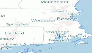
Map - T. F. Green Airport (Theodore Francis Green State Airport)
Map


Country - United_States
 |
 |
| Flag of the United States | |
Indigenous peoples have inhabited the Americas for thousands of years. Beginning in 1607, British colonization led to the establishment of the Thirteen Colonies in what is now the Eastern United States. They quarreled with the British Crown over taxation and political representation, leading to the American Revolution and proceeding Revolutionary War. The United States declared independence on July 4, 1776, becoming the first nation-state founded on Enlightenment principles of unalienable natural rights, consent of the governed, and liberal democracy. The country began expanding across North America, spanning the continent by 1848. Sectional division surrounding slavery in the Southern United States led to the secession of the Confederate States of America, which fought the remaining states of the Union during the American Civil War (1861–1865). With the Union's victory and preservation, slavery was abolished nationally by the Thirteenth Amendment.
Currency / Language
| ISO | Currency | Symbol | Significant figures |
|---|---|---|---|
| USD | United States dollar | $ | 2 |
| ISO | Language |
|---|---|
| EN | English language |
| FR | French language |
| ES | Spanish language |